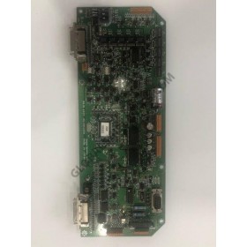
12” Touchscreen Chartplotter with Full HD In-plane Switching (IPS) Display
Features a 12” full HD IPS touchscreen display preloaded with both BlueChart® g3 U.S. coastal and LakeVü HD maps featuring Navionics® data and Auto Guidance¹ technology
Fully network capable with NMEA 2000® connectivity and the Garmin Marine Network
Includes ANT® technology and Wi-Fi® networking
Garmin SailAssist™ feature provides critical sailing data and displays prerace guidance for racers
SmartMode™ station controls enable quick, one-touch access to the information you need
Serious cruisers, sailors and sail racers demand serious equipment. The easy-to-use, easy-to-install GPSMAP 8612 chartplotter delivers MFD performance in a combo-size package. It features a 12” full HD IPS touchscreen display for wider viewing angles, superior clarity and sunlight readability, even with polarized sunglasses. Multiple displays can be flat mounted edge-to-edge to create a sleek glass helm look or can be mounted flush. It also provides standard USB touch output for use as a touchscreen monitor for Windows® and Mac® operating systems.
JLR-7700Mk2 DGPS navigator pinpoints your precise location by means of a simultaneous reception of 12 satellites The DGPS navigator composed of a DGPS receiver and a LCD display unit ensures very accurate position fix.
Capable of SBAS (WAAS/EGNOS/MSAS) correctionRAIM function is available12-Channel Parallel for simultaneous reception of 12 satellites.IEC61162-1, NMEA0183 Output
12” Touchscreen Chartplotter/Sonar Combo with Full HD In-plane Switching (IPS) Display
Features a 12” full HD in IPS touchscreen display
Built-in support for the full suite of Garmin sonar capabilities
Fully...
12” Touchscreen Chartplotter/Sonar Combo with Full HD In-plane Switching (IPS) Display
Features a 12” full HD IPS touchscreen display preloaded with both BlueChart® g3 U.S. coastal and LakeVü HD maps featuring...